Skip to content
Home
About
Welcome
Who We Are
Governance
Staff
Apply
Directions
Accessibility
Communities
Barrington
Brookfield
Dover
Durham
Farmington
Lee
Madbury
Middleton
Milton
New Durham
Newmarket
Northwood
Nottingham
Rochester
Rollinsford
Somersworth
Strafford
Wakefield
Engage
Civil Rights
Committees
Notices and News
Blog
Social Media
Press Releases
Newsletter
Bits and Pieces
Calendar
Measure
Mapping and GIS
Data Collection
Performance Measures
Data Snapshot
Dashboards
Plan
Core Plans
Project Portal
COVID-19 Recovery
Municipal Assistance
Economic Development
Transportation
UPWP
Environment
Climate Adaptation and Resilience
Conservation and Natural Resources
Energy
Watershed Planning
Services
Reference
Acronyms
Document Library
Map Gallery
Meeting Material Archive
Resources
Economic Development Resources
Environment Resources
Age-Friendly Resource Guide
Land Use Resources
Mapping/GIS Resources
Transportation Resources
Search
Topic: Water Resources
Standard Map Set – Middleton
May 28, 2020
Standard Map Set – Milton
May 28, 2020
Standard Map Set – New Durham
May 28, 2020
Standard Map Set – Newmarket
May 28, 2020
Standard Map – Water Resources
May 28, 2020
Environment Resources
May 15, 2020
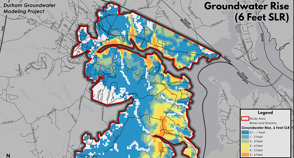
Durham Groundwater Rise Modeling
March 1, 2020
Water Resources (Groundwater) Interactive Standard Map
February 18, 2020
Water Resources (Surface Water) Interactive Standard Map
February 18, 2020
Open Data Portal
February 14, 2020
New Durham Build Out Analysis – Water Resources Map
January 21, 2020
New Durham Build Out Analysis – Steep Slopes and Aquifers Map
January 21, 2020
Lee Floodplain Study – 2005 Estimated Floodplain
December 18, 2019
Lee Floodplain Study – 2050 Estimated Floodplain
December 18, 2019
Northwood Hazard Mitigation Plan – Water Resources Map
August 19, 2019
Madbury Hazard Mitigation Plan – Water Resources Map
June 25, 2019
MS4 Assistance
September 28, 2018
Durham Permeable Reactive Barrier
September 1, 2018
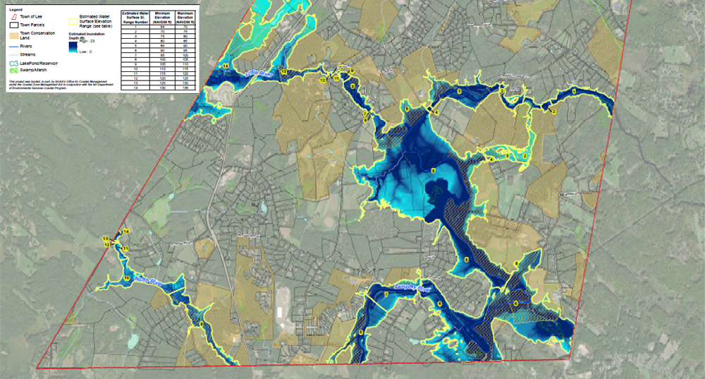
Lee Inundation Mapping
January 1, 2018
Watershed Planning
September 28, 2016
Page
1
Page
2
Page
3
Page
4