Skip to content
  • Home
  • About
    • Welcome
    • Who We Are
    • Governance
    • Staff
    • Apply
    • Directions
    • Accessibility
  • Communities
    • Barrington
    • Brookfield
    • Dover
    • Durham
    • Farmington
    • Lee
    • Madbury
    • Middleton
    • Milton
    • New Durham
    • Newmarket
    • Northwood
    • Nottingham
    • Rochester
    • Rollinsford
    • Somersworth
    • Strafford
    • Wakefield
  • Engage
    • Civil Rights
    • Committees
    • Notices and News
    • Blog
    • Social Media
    • Press Releases
    • Newsletter
    • Bits and Pieces
    • Calendar
  • Measure
    • Mapping and GIS
    • Data Collection
    • Performance Measures
    • Data Snapshot
    • Dashboards
  • Plan
    • Core Plans
    • Project Portal
    • COVID-19 Recovery
    • Municipal Assistance
    • Economic Development
    • Transportation
      • UPWP
    • Environment
      • Climate Adaptation and Resilience
      • Conservation and Natural Resources
      • Energy
      • Watershed Planning
  • Services
  • Reference
    • Acronyms
    • Document Library
    • Map Gallery
    • Meeting Material Archive
    • Resources
      • Economic Development Resources
      • Environment Resources
      • Age-Friendly Resource Guide
      • Land Use Resources
      • Mapping/GIS Resources
      • Transportation Resources

Topic: Data Analysis

Seacoast Economic Development Stakeholder RHNA Update Presentation

February 7, 2023

Council on Housing Stability Regional Leadership and Coordination Workgroup RHNA Presentation

February 1, 2023

Council on Housing Stability “How Much Housing Does NH Need?” Presentation

January 24, 2023

Bicycle & Pedestrian Counting Pilot 2022

January 19, 2023
Cover slide from the December 2022 Commissioner Meeting RHNA presentation featuring six staff photos

RHNA Update – December 2022 Commission Meeting Presentation

December 29, 2022
Cover slide from the Barrington Master Plan Community Forum

Barrington Master Plan Community Forum Presentation

December 21, 2022

PLAN OPD Webinar – Housing Trends in New Hampshire: Diving Into The Data Presentation

December 15, 2022
screenshot of the cover slide from SRPC's Housing Forum presentation

RHNA Housing Forum Presentation

September 26, 2022

RHNA Commissioner Workshop – September 2022 Commission Meeting Presentation

September 22, 2022

Regional Data Snapshot 2022

April 25, 2022

Regional Data Snapshot Map Viewer

April 20, 2022
Screenshot of the cover of the 2020 building permit report, which features three images of new construction within the region.

SRPC Annual Building Permit Report 2020

March 28, 2022

Durham Groundwater Modeling Maps

March 7, 2022
Notices and News SRPC Latest Report icon

SRPC’s Latest Report: Durham Groundwater Modeling

February 25, 2022
Cover of the Sea Level Rise Impacts on Groundwater Levels and Water Quality Report with a groundwater rise map of Durham

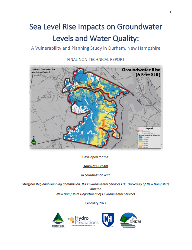
Sea Level Rise Impacts on Groundwater Levels and Water Quality: A Vulnerability and Planning Study in Durham, New Hampshire

February 25, 2022
Photo of a home for sale in Dover, NH

Regional Housing Needs Assessment 2023

February 9, 2022
Cover of Northwood RSMS 2021 Report

Northwood Road Surface Management System Report

December 14, 2021
Thumbnail for the 2020 Census Demographics Viewer

2020 Census: Demographics Map Viewer

October 8, 2021

Data Snapshot

August 16, 2021

Mapping and GIS

August 16, 2021
Page1 Page2 Page3 Page4 Page5

Translate

en English
ar Arabiczh-CN Chinese (Simplified)nl Dutchen Englishfr Frenchde Germanid Indonesianit Italianpt Portugueseru Russianes Spanish

Learn More

  • Accessibility
  • About
  • Civil Rights
  • Engage
  • Acronyms
  • Directions
  • Accessibility
  • About
  • Civil Rights
  • Engage
  • Acronyms
  • Directions

Keep In Touch!

Facebook Youtube Instagram Linkedin

Contact Us

150 Wakefield St, Suite 12

Rochester, New Hampshire 03867

Tel. (603) 994-3500

Fax. (603) 994-3504

srpc@strafford.org

JOIN OUR EMAIL LIST

Select list(s) to subscribe to


By submitting this form, you are consenting to receive marketing emails from: . You can revoke your consent to receive emails at any time by using the SafeUnsubscribe® link, found at the bottom of every email. Emails are serviced by Constant Contact