It’s Culvert Season
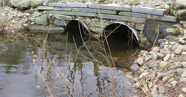
Despite the vast knowledge and awareness of rivers and their issues, stream crossings continue to challenge public works and highway departments across the state. One of the most amazing and dynamic systems in nature, rivers are constantly changing. While every river, especially in the Granite State, is prone to flooding, people are often surprised when the rivers themselves change, sometimes dramatically [Source: NH Department of Environmental Services – Environmental Fact Sheet Co-GEO-10].
Across the state of New Hampshire, there are thousands of road-stream crossings, some of which have created obstructions to the adequate passage of water, sediment, and wildlife. River and stream continuity is aimed at reducing impediments to the movement of fish, wildlife and other aquatic life that require instream passage, and often has not been considered during the design and construction of stream crossings (culverts and bridges). Many crossings are barriers to fish and wildlife. Even crossings that were not barriers when originally constructed, may now be barriers because of stream erosion, mechanical breakdown of the crossings, or changes in the upstream or downstream channel shape.
The objective of the New Hampshire Culvert Assessment Program is to complete a comprehensive inventory of drainage crossings (culverts & bridges) serving public roadways in all eighteen Strafford Regional Planning Commission communities, in order to provide state agencies and municipal public works & planning departments with information necessary to appropriately prioritize culvert repair and replacement projects. Through this program, the Commission believes that by assisting the state and municipalities to reduce future roadway closures, hazards, and property damage, improvements will be made to the environmental quality of our local rivers and their tributaries. This assessment program is the first step toward developing and completing the regional infrastructure database under the Unified Planning Work Program (UPWP), financed by the Federal Highway Administration (FHWA).
Currently, the Strafford Regional Planning Commission staff have completed three (3) summer field collection seasons starting in June 2010. Of the seven (7) communities visited so far, five (5) culvert inventories have been submitted to and validated by the New Hampshire Geological Survey (NHGS).